The Manipur Myanmar Border Dispute: Old Demarcation, New Fencing and a Changing Security Geography

# Sanket Kiranti
The Myanmar border adjoining India’s northeastern state of Manipur has once again moved to the center of political and security debate. On the surface, the controversy appears to involve a number of boundary pillars, the construction of new fencing and the possible adjustment of about 3.6 square kilometers of territory. The roots of the issue, however, go much deeper.
The colonial legacy of the boundary, the 1967 India Burma border agreement, sections that remained incompletely demarcated for decades, ethnic communities living across both sides of the frontier, Myanmar’s civil war, Manipur’s internal ethnic conflict and India’s changing border security policy have all converged in the present dispute.
It would therefore be misleading to interpret the current situation as a sudden new territorial confrontation between India and Myanmar. Most of the international boundary between the two countries is established and operationally accepted. The problem is concentrated primarily in certain specific sectors where questions remain over the precise location of boundary pillars, interpretation of older maps and the exact alignment of the border on the ground.
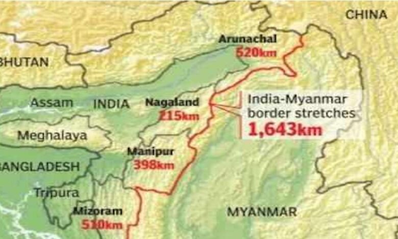
India and then Burma signed a border agreement in Rangoon on March 10, 1967. After ratification by both governments, the instruments of ratification were exchanged in New Delhi on May 30 of the same year. Historical documents refer to about 1,450 kilometers of boundary being formalized in that period. The currently accepted length of the India Myanmar international boundary administered by India is about 1,643 kilometers. These figures come from different historical, surveying and administrative contexts and should not be treated as contradictory measurements of exactly the same reference.
The 1967 agreement clarified the political foundation of the boundary, but it did not make every point in the difficult mountainous terrain completely undisputed in practical terms. In some areas adjoining Manipur, questions remained over the location of boundary pillars because of differences involving rivers, ridgelines, watersheds, traditional villages and interpretations of older maps.
This is why joint inspection of boundary pillars, verification and the installation of subsidiary markers where necessary have repeatedly appeared in official discussions between India and Myanmar. A bilateral joint statement in 2017 also acknowledged the need to resolve remaining technical demarcation issues while respecting the boundary that had already been agreed.
One important conclusion follows from this history. The present problem was not suddenly created in 2026. Rather, technical and geographical ambiguities that had remained unresolved for decades have now become politically more sensitive.
In 2018, controversy over Boundary Pillar 81 near Kwatha Khunou in Manipur’s Tengnoupal district triggered a major political reaction. Local residents and some organizations alleged that the pillar had been shifted in Myanmar’s favor. Officials associated with India’s Ministry of External Affairs, Ministry of Home Affairs and Survey of India subsequently examined the area.
The Indian government later stated in an official response in Parliament that it had found no evidence that Myanmar had shifted the boundary pillar or encroached upon Indian territory. The then Manipur government also rejected claims that the pillar had been relocated. Yet the controversy itself exposed the depth of local mistrust surrounding the border demarcation process.
That mistrust remains one of the most important keys to understanding the current crisis.
For many Naga, Kuki Zo and other border communities in Manipur, the international boundary is not simply a line separating two sovereign states. Family ties, languages, ethnic identities, farming practices, customary forest use and cultural relationships extend across both sides of the frontier. Many of these connections existed long before the modern international border.
As a result, what may appear to New Delhi or Naypyidaw as a technical adjustment of several hundred meters can be perceived locally as a question of ancestral land, identity and historical rights.
For decades, India partly accommodated this social reality through the Free Movement Regime, which allowed certain border communities to travel limited distances across the boundary without conventional passport and visa requirements. That approach began to change sharply after Myanmar’s military seized power in February 2021.
Conflict expanded across Myanmar’s Chin, Sagaing and other border regions among the military, ethnic armed organizations and resistance groups. Large numbers of people were displaced. India increasingly described cross border militant activity, narcotics trafficking, arms smuggling and unauthorized movement as growing security concerns.
Against this background, the Indian government moved in 2024 to construct extensive fencing along the India Myanmar border. The decision to end the Free Movement Regime became part of the same new security approach. India has linked these measures to internal security, the control of smuggling and the protection of social and demographic stability in its northeastern border states.
This fencing project is perhaps the most important structural reason why the old demarcation issue has become urgent again.
For decades, a degree of ambiguity could be managed along a frontier defined by mountains, forests, streams and boundary pillars. Once that boundary is converted into a permanent physical fence, however, the ownership of every meter of land has to be determined with far greater precision. Ambiguities that could once be managed administratively now have to be resolved physically.
India has advanced plans to fence much of the approximately 1,643 kilometer boundary and develop related border infrastructure, with the projected cost reported at around 310 billion Indian rupees. A project of that scale inevitably brings unresolved sections of the boundary back into immediate focus.
The present controversy became even more sensitive after a report published in July 2026.
The Diplomat reported that it had reviewed an internal Indian government document dated May 26, 2026, suggesting that a territorial adjustment involving about 1.4 square miles, or roughly 3.6 square kilometers, was under consideration as one possible way of resolving incomplete demarcation between Boundary Pillars 65 and 68 in Manipur’s Chandel district.
The report triggered a strong political reaction in Manipur.
Naga organizations said that no decision affecting ancestral territory should be taken without the consent of local communities. Civil society groups associated with the Meitei community also said that any plan to transfer Manipur territory to Myanmar would be unacceptable. Opposition political leaders demanded that the central government clarify the actual status of the border discussions.
This is precisely where a clear distinction must be maintained between verified facts and political concern.
There is no evidence that India has already transferred 3.6 square kilometers of territory to Myanmar. The report referred to a possible proposal under consideration. The Indian government has not publicly announced any final decision to transfer such territory. The official account of the high level India Myanmar border security dialogue held in July 2026 also did not announce any territorial exchange.
On the basis of currently available information, it is therefore more accurate to understand the issue as a reported possible technical option for resolving incomplete demarcation, not as a completed transfer of territory.
Political sensitivity, however, does not wait for final legal confirmation. In Manipur, land is deeply connected with ethnic politics and security.
Since 2023, violence between Meitei and Kuki Zo communities has profoundly divided the state’s social and political geography. In some areas, tensions and violent incidents have also emerged between Naga and Kuki communities. Land, district administration, political representation and community security have all become highly sensitive issues.
In such an environment, international border demarcation with Myanmar cannot remain a purely technical exercise between foreign ministries and survey officials. Questions about which village, forest or customary area falls on which side of the boundary can become directly linked to the political future of local communities.
Myanmar’s civil war adds another layer of difficulty. The India Myanmar frontier is no longer a conventional border adjoining a fully stable state structure. Different border areas in Myanmar are influenced to varying degrees by the military authorities, ethnic armed organizations and resistance groups. In some places, the reach of the central state remains weak.
From New Delhi’s perspective, fencing, surveillance and tighter border management can help reduce unauthorized crossings, insurgent movement, arms trafficking and narcotics smuggling. From the perspective of border communities, however, the same fence may permanently divide historically connected ethnic populations.
This is where the central contradiction between security requirements and local identity emerges.
The issue also has a wider strategic dimension through India’s Act East Policy. India’s Look East Policy, launched in 1991, was given a more active economic, strategic and connectivity oriented form after 2014 under the Act East Policy. Within this framework, Myanmar is one of India’s most important land gateways to Southeast Asia.
Projects such as the India Myanmar Thailand Trilateral Highway, the Kaladan Multimodal Transit Transport Project and broader plans to expand the economic and strategic connectivity of northeast India all depend on a stable and secure border environment.
For New Delhi, therefore, the Myanmar frontier is not only a security concern. It is directly connected to India’s Southeast Asia policy, trade strategy, infrastructure development and regional geopolitical ambitions.
Yet another contradiction appears here. India wants to secure the border while expanding eastward economic connectivity. At the same time, excessively rigid border management risks weakening the very social and economic relationships that have existed across the frontier for generations.
This is why a durable solution to the Manipur Myanmar border issue cannot be achieved through fencing alone.
India and Myanmar need joint technical surveys. Boundary pillar locations, maps and the physical geography of the frontier require scientifically credible and transparent clarification. But the communities living along the border must also be informed and consulted in a manner they can trust.
If the concerns of Naga, Kuki Zo and other affected communities regarding ancestral land and customary use are ignored in favor of a purely central level agreement, the international boundary may become clearer while local political conflict becomes deeper.
Another major weakness exposed by the current controversy is the absence of sufficient public information.
When governments fail to explain technical processes clearly, the resulting information vacuum is quickly filled by rumor, political interpretation and communal anxiety. The controversy surrounding the reported 3.6 square kilometer adjustment is a clear example. The fact that a media report based on an internal document could trigger such widespread political concern demonstrates how fragile trust has become between the state and border communities.
The appropriate response for India is not to weaken border security. But neither should border security and local legitimacy be treated as mutually exclusive.
Modern border management is not only about fences, security posts and surveillance technology. It also requires accurate maps, joint surveys, legal clarity, local consultation, control of cross border crime and mechanisms for preserving legitimate human connections.
The present situation in Manipur also points to a broader transformation. The state’s security problem is no longer confined to internal ethnic conflict. Myanmar’s political instability, cross border ethnic ties, displacement, armed activity and India’s new border policy have connected Manipur’s domestic politics directly with India’s foreign and security policy.
The current controversy therefore cannot be adequately understood simply as a border dispute between India and Myanmar.
It is a complex intersection of the colonial legacy of boundary making, unfinished demarcation, the security requirements of the modern state and the perspectives of communities that regard the frontier as part of their historical and cultural geography.
Based on the information currently available, India and Myanmar are not entering a new territorial war. Most of their international boundary remains established. What has changed is that technical ambiguities left unresolved for decades in some parts of Manipur have become increasingly difficult to postpone because of India’s large scale border fencing project.
Likewise, there is no sufficient basis to conclude that approximately 3.6 square kilometers of Indian territory have already been transferred to Myanmar. A report has emerged suggesting that a possible territorial adjustment was under consideration, but no final government decision has been publicly announced.
The deeper crisis is therefore one of trust rather than boundary lines alone.
New Delhi wants a secure and manageable frontier. Border communities want their ancestral lands, cultural relationships and identities to remain protected. Myanmar, meanwhile, continues to struggle with a severe internal conflict. Unless these three realities are addressed together, a dispute over a handful of boundary pillars could develop into a much larger political problem.
The future of the Manipur Myanmar frontier will ultimately be determined not only by where a fence is built. It will also depend on how seriously the state listens to the people who live on both sides of that boundary.