Kerung–Rasuwa Disaster’s Scientific Message: The Time Has Come for a Nepal–China Himalayan Security Framework

Pasang Lhamu
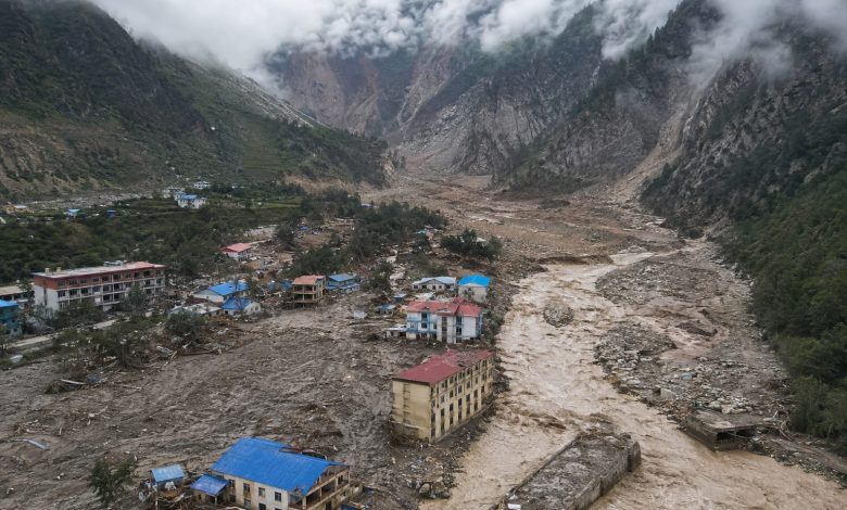
The Kerung–Rasuwa disaster of August 26 did more than confront Nepal with a devastating natural tragedy. It also raised profound questions about the rapidly changing Himalayan environment, transboundary disaster risks and the limitations of our traditional understanding of security. A detailed scientific study released by researchers from institutions under the Chinese Academy of Sciences and several universities is therefore especially significant. The study does not merely examine where the disaster originated. It seeks to explain how an ice-rock avalanche that began at high altitude evolved into a massive destructive debris flow as it travelled roughly 22 kilometres through a mountain gorge. For Nepal, the importance of this research goes far beyond accepting the findings of a foreign scientific team. It sends a clear message that the Himalayas can no longer be understood as isolated geographical spaces, but as an interconnected natural security system.
One of the most important contributions of the study is that it does not reduce the disaster to a single moment. The initial collapse of ice and rock was not, by itself, the full explanation for the scale of destruction. As snow, rock and other material moved downstream, the flow eroded riverbanks, incorporated soil, boulders and accumulated debris, and interacted with river water, increasing both its volume and destructive energy. In other words, an instability that began high in the mountains multiplied in force as it moved downstream. Describing such an event simply as “a landslide” or “a flood” obscures the true architecture of the hazard. Modern Himalayan disaster science increasingly shows that the entire chain, from the source zone to the final affected settlements, must be studied as one integrated system.
This conclusion is particularly important for Nepal because much of its Himalayan frontier is connected with China. Rivers do not recognize political borders. Neither do glaciers, glacial lakes, rocks, rainfall, temperature systems or river basins. A geological or cryospheric change in China’s Xizang region can affect Nepal, just as instability on the Nepali side of the high Himalayas can affect Kerung or other cross-border areas. This reality demonstrates that Himalayan security is no longer only a national responsibility. It is increasingly a shared transboundary responsibility.
The scientific caution adopted by the Chinese researchers is equally noteworthy. The study indicates that rainfall in the source area had been below average in the months before the disaster and that there was no major rainfall immediately before the event. This makes it difficult to attribute the disaster simply to short-term heavy precipitation. The researchers instead point to possible links involving unusually warm spring and summer conditions, glacier movement, enhanced melting and permafrost degradation, all of which may have weakened the stability between ice and rock. Yet they have not claimed that a single definitive trigger has already been identified. That restraint is a strength of responsible science.
For that reason, the study should not be used as a political document to claim that climate change has been conclusively proven as the direct cause of this particular disaster. What it does provide is stronger scientific justification for taking long-term warming, glacier instability and structural changes in high-altitude terrain much more seriously. Climate-related risks do not always operate through a simple linear chain. In one place a glacial lake may expand; elsewhere a glacier may thin, permafrost may degrade, or the structural relationship between ice and rock may weaken. Eventually, a localized instability can trigger a cascading disaster of far greater magnitude. The Kerung–Rasuwa event appears to illustrate precisely this complexity.
Another particularly important finding concerns possible anomalous signals in the hours before the main collapse. These signals do not yet constitute a ready-made early-warning system. But if seismic activity, glacier movement, satellite imagery, temperature, local video feeds, terrain measurements and river-flow data can be integrated and analysed in near real time, even a few hours or minutes of warning could save lives in extremely high-risk mountain environments. We may not be able to stop a mountain from collapsing, but we may be able to move people out of danger. That is where the human value of science becomes most visible.
Nepal should therefore use this study as an opportunity to rethink the philosophy of its disaster early-warning system. At present, much of our warning architecture remains focused on rising river levels or deteriorating weather conditions. The Himalayan safety system of the future must begin much higher, at the source. Glacier velocity, glacial lake expansion, ice-rock instability, permafrost conditions, seismic anomalies, surface temperature, satellite radar and automated high-altitude monitoring stations should be brought together within an integrated national system. Nepal needs to move beyond flood forecasting toward a broader Himalayan multi-hazard early-warning architecture.
This is where cooperation with China becomes strategically important. China possesses substantial capabilities in Earth-observation satellites, high-altitude meteorological stations, remote sensing, seismic monitoring, artificial intelligence-assisted data analysis and large-scale scientific data processing. Nepal possesses equally important knowledge of southern Himalayan watersheds, local geography, river systems, community-level experience and direct exposure to downstream risk. Combining these strengths could make it possible to develop a model transboundary disaster early-warning system for the Nepal–China Himalayan frontier, not only for Kerung–Rasuwa but across the wider border region.
Such cooperation should not remain a one-way arrangement in which one country simply provides information to the other. Nepal and China could establish a joint Himalayan risk observation mechanism, a shared scientific data platform, real-time information-exchange protocols and permanent joint research teams. High-risk transboundary rivers, glaciers and glacial lakes could be jointly identified and classified according to risk. If abnormal glacier movement, major ice-rock displacement, sudden thermal changes or unusual seismic signals were detected, both countries’ relevant agencies could receive alerts simultaneously.
This would require more than diplomatic understanding between Kathmandu and Lhasa. Nepal’s Department of Hydrology and Meteorology, National Disaster Risk Reduction and Management Authority, Department of Mines and Geology, universities, security agencies and local governments should be technically linked with their Chinese counterparts. In sensitive areas such as Kerung–Rasuwagadhi, local administrations and border-security institutions should also be included directly within the scientific warning chain. A Himalayan disaster may not allow enough time for an alert to travel first to the capital and then back down through traditional administrative channels.
The study also offers another major lesson: risk is not determined solely by how much rock or ice collapses at the source. It also depends on how much additional material can be entrained downstream, how much energy is added by river water, and what settlements, bridges, hydropower stations, roads, tunnels, communication systems and trade infrastructure lie along the path. This means that Nepal’s future infrastructure planning cannot rely only on historical flood levels. Cascading-disaster scenarios, in which one failure triggers another, must become part of engineering and planning standards.
This is especially important in corridors such as Bhote Koshi–Trishuli. Hydropower plants, roads, bridges, tunnels, transmission lines and trade infrastructure should not be treated as isolated projects, but as interdependent systems located within a shared hazard environment. When one bridge is destroyed, transport is interrupted. When transport is cut, rescue becomes harder. When electricity fails, communications and pumping systems weaken. When communications collapse, rescue teams lose access to reliable information. Within hours, a natural disaster can become an infrastructure crisis, a supply-chain crisis and ultimately a national-security challenge.
For this reason, the Kerung–Rasuwa disaster should also be viewed as an opportunity to open a new chapter in Nepal–China relations. Bilateral ties have long focused on trade, tourism, infrastructure and cultural exchange. A permanent “Himalayan security partnership” should now become another pillar of cooperation. This does not imply a military alliance. It means building a system that protects lives, infrastructure, rivers, glaciers and transboundary economic corridors through shared scientific knowledge and coordinated preparedness.
The speed with which Chinese scientists combined satellite imagery, terrain data, seismic records, field-monitoring video and other sources to reconstruct the disaster sequence deserves recognition. Nepal should respond positively by ensuring that its own scientific institutions participate at an equal level in future work. The next stage should not be framed as “China studying Nepal,” but as “Nepal and China jointly studying the Himalayas.” Scientific equality and shared ownership are essential for building long-term confidence.
Nepal must also strengthen its own national capacity. Using technology from a friendly country is not a weakness, but failing to build domestic scientific capability would be. Nepal needs long-term investment in cryosphere research, automated high-altitude monitoring stations, satellite-data analysis, university research funds and the training of young glaciologists, geologists and disaster scientists. Cooperation with China should therefore be linked directly to national capacity building rather than dependency.
Hundreds of families have suffered pain from the Kerung–Rasuwa disaster that no scientific paper can erase. But if the data generated by this tragedy can help protect another village, another market or another generation, then the research will have real meaning. The most responsible tribute to those who lost their lives is not only to build memorials, but to learn scientifically from the circumstances of their deaths and use that knowledge to protect others.
For generations, we have viewed the Himalayas as symbols of beauty, tourism, spiritual heritage and national pride. We must now also understand them as a dynamic and sensitive natural security system. The Chinese scientific study of the Kerung–Rasuwa disaster helps make that reality clearer. It is not merely an example of China’s growing scientific capability; it also provides Nepal with a basis for rethinking its own Himalayan security policy.
A major future dimension of Nepal–China relations could therefore be joint monitoring of transboundary Himalayan risks, shared early warning, open scientific data exchange, collaborative research and coordinated emergency response. Political borders may divide countries, but mountains, rivers and climate operate within the same natural system. Himalayan security must therefore become an area of cooperation, not competition.
The Kerung–Rasuwa disaster has taught us this lesson at an enormous human cost. The question now is no longer simply what science has discovered. The real question is how quickly Nepal and China can translate that science into policy. If this tragedy can lead to the creation of an effective Nepal–China Himalayan disaster early-warning and security framework, then the suffering of August 26 can at least be transformed into life-saving knowledge for the future. That is the most constructive and far-reaching possibility before us.