Langtang Lirung Ice-Rock Avalanche Sounds Alarm Over Climate Change, Cascading Hazards and Early Warning in the Himalayas

Dragon Media News Desk
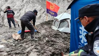
The massive ice-rock avalanche that struck Nepal’s high-altitude region on August 26 unleashed a fast-moving flow of mud, rock, ice and water, causing heavy casualties on both sides of the China-Nepal border.
Citing local authorities, the Global Times reported that as of Friday, 31 people had been confirmed dead and 531 others remained missing in the Kyirong Port area of southwest China’s Xizang Autonomous Region. Chinese authorities have also been conducting assessments of continuing risks in the affected zone.
Scientists say, however, that the August 26 event should not be viewed as an isolated natural disaster. It offered a stark warning of how rapidly warming high-mountain environments can destabilize glaciers, rock slopes and permafrost, creating sudden and potentially catastrophic hazards.
As glaciers retreat and large ice masses become increasingly unstable, ice avalanches and ice-rock avalanches are emerging as a growing threat across high-altitude regions. One of the greatest challenges is that accurately predicting when and where such events will occur remains extremely difficult.
From the Alps and Andes to the Caucasus and the Qinghai-Xizang Plateau, major ice avalanches have repeatedly destroyed settlements and reshaped mountain valleys. The central question is therefore no longer whether such events can occur, but how climate change is altering their scale, speed, reach and destructive potential.
Langtang Lirung and Lessons from Peru
Alton C. Byers, a senior research affiliate at the Institute of Arctic and Alpine Research at the University of Colorado Boulder, said the recent disaster at Mount Langtang Lirung shares important characteristics with several major historical ice-avalanche events.
He pointed in particular to disasters on Mount Huascarán in Peru’s Andes.
In 1962, a massive glacier detached from Huascarán’s north peak and travelled about 15 kilometres in just seven minutes. According to the US Geological Survey, the debris descended about 4,000 metres and engulfed nine villages and towns in its path.
Eight years later, in 1970, a magnitude-7.7 earthquake triggered an even larger collapse on the same mountain. Up to 100 million cubic metres of rock, snow and ice buried the town of Yungay at speeds of up to 335 kilometres per hour, killing more than 18,000 people, according to the US Geological Survey.
Byers said the latest Langtang Lirung event similarly demonstrated how an initial collapse can transform into a much larger secondary disaster by entraining mud, rock and water as it moves downslope.
Scientists also caution against treating an avalanche in one location as an entirely isolated event. The 2016 Aru Glacier avalanche in Xizang highlighted the importance of regional monitoring. Ice-core records from the nearby Guliya Glacier indicated a warming and wetting trend, strengthening calls for broader monitoring not only of glaciers but also of lakes, grasslands and interconnected ecosystems.
Growing Risk of Cascading Disasters
Amod Mani Dixit, founder of the Nepal National Society for Earthquake Technology, senior geologist and disaster risk management specialist, said high-mountain regions must increasingly prepare for complex and interconnected hazards rather than single-event disasters.
Dixit, also a PIFI visiting scientist at the Aerospace Information Research Institute of the Chinese Academy of Sciences, said one episode of intense warming could trigger an ice-rock avalanche, which might then breach a moraine dam. If heavy rainfall occurred at the same time, the result could be a compound disaster involving several interacting hazards.
Such events, he warned, could overwhelm conventional protective systems designed to address only one type of threat at a time.
Rock and Permafrost Matter Too
Jakob Steiner, a geoscientist at the University of Graz in Austria, compared the Langtang Lirung ice-rock avalanche with the deadly February 2021 disaster in Chamoli, in India’s Uttarakhand state.
According to Steiner, both disasters involved failure of the underlying bedrock, which then pulled the overlying ice into the collapse.
The similarity underscores the importance of looking beyond the direct effects of warming on glaciers. Scientists must also understand how climate change affects rock stability, permafrost and high-altitude slopes.
Steiner said the Langtang Lirung disaster may not have been the largest in modern records in terms of its initial volume, but its runout distance and overall impact were extraordinary.
He argued that existing estimates of how large and far-reaching such events can become may now need to be fundamentally reassessed.
“We cannot just go on as we used to,” Steiner said.
He added that early-warning systems, monitoring methods and risk assessments must be adapted to new realities, requiring cooperation among experts from different scientific disciplines and countries.
Why Himalayan Risks Are Increasing
Ice avalanches and ice-rock avalanches are among the most destructive hazards associated with the cryosphere. Their dynamics are complex, their predictability remains limited and their consequences can be catastrophic.
Across the Qinghai-Xizang Plateau and the Himalayas, rapid warming is accelerating glacier retreat. Glacial lakes are increasing in both number and size, while some ice masses are becoming less stable.
Dixit said rapid cryosphere degradation can generate cascading risks long after the initial retreat of a glacier.
As glaciers recede, rock walls that were once supported or protected by ice can weaken. Loose glacial deposits may destabilize and move downslope, while large amounts of sediment can be carried into river systems.
As a result, downstream communities may remain exposed to hazards for years after visible glacier retreat has taken place.
Dixit called for risk-based planning for settlements and infrastructure. He said multi-hazard risk mapping should cover entire valley systems, from river channels and lower settlements to mountain slopes and high-altitude ridges.
Satellite Monitoring and Early Warning
Byers said one of the highest priorities in high-risk mountain regions should be the development of effective early-warning systems for large-scale disasters.
Downstream communities, he said, should be prepared to evacuate immediately when alerts arrive through mobile phones, sirens or other warning systems.
But before such systems can be effective, authorities must first identify where the greatest risks lie.
In Nepal, particular attention should be given to watersheds where large glaciers and unstable ice masses dominate the upper reaches while towns and settlements are located downstream along river valleys.
Byers emphasized the importance of regular and rigorous satellite-image analysis. High-risk situations may involve massive overhanging ice on a steep mountain slope with densely populated communities only a few kilometres downstream.
Continuously monitoring all such high-risk areas, however, remains a major challenge.
The August 26 Langtang Lirung-Kyirong disaster has reinforced one essential lesson: identifying a hazard is not enough.
Warnings must reach people in time, communities must understand what they mean, and evacuation plans must already be in place before disaster strikes.
The scientific message is clear: early warning has value only when it leads to early action.
Source: Global Times