Chinese Report Rejects Philippine Claims in South China Sea as Historically and Legally Unfounded
Dragon Media News Desk
A new report released by the China Institute for Marine Affairs under China’s Ministry of Natural Resources has concluded that the Philippines’ territorial claims over Huangyan Dao and parts of the Nansha Qundao lack credible historical and legal foundations.
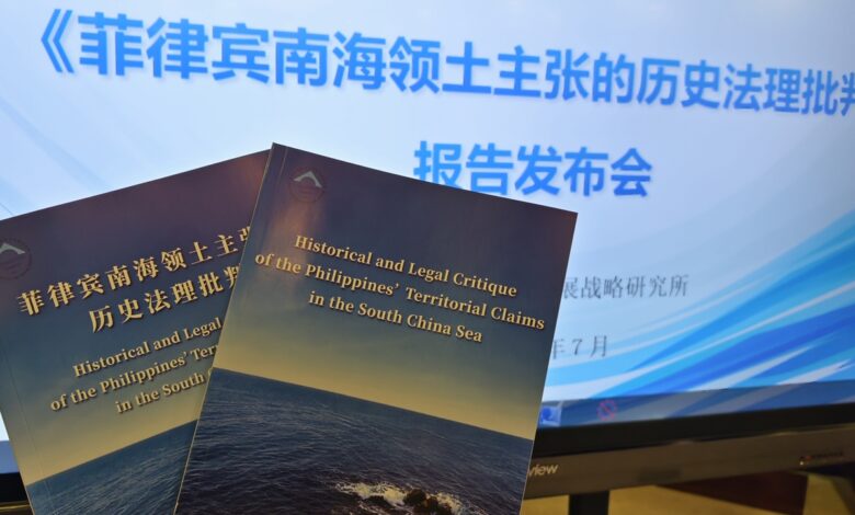
The report, titled “Historical and Legal Critique of the Philippines’ Territorial Claims in the South China Sea,” was released on Wednesday. It examines the Philippines’ use of old maps, international treaties, geographical proximity and claims of prior discovery and occupation to support its position in the South China Sea.
According to the institute, the arguments advanced by Manila have changed over time and, in some instances, contradict one another. The report says the Philippines has used presidential decrees, constitutional amendments and domestic legislation since the 1970s to extend its claims over parts of the Nansha Qundao and Huangyan Dao.
The report states that the Philippines did not formally claim Huangyan Dao before 1997. It says Manila later presented several different grounds for sovereignty, including the argument that the feature lies within the Philippine exclusive economic zone, that it was first discovered and occupied by the Philippines, and that historical treaties defining Philippine territory could be reinterpreted to include it.
The Chinese institute argues that these shifting positions demonstrate a lack of historical and legal consistency.
The report rejects the argument that Huangyan Dao belongs to the Philippines merely because it lies within its claimed exclusive economic zone. It notes that rights over an exclusive economic zone or continental shelf do not automatically establish sovereignty over land territory or maritime features.
Under the law of the sea, maritime entitlements are generally derived from sovereignty over land. Although the United Nations Convention on the Law of the Sea grants coastal states sovereign rights over natural resources within their exclusive economic zones, those rights do not, by themselves, determine ownership of disputed islands, reefs or other land features.
Chen Xidi, a researcher at the China Institute for Marine Affairs and one of the report’s lead authors, said maritime jurisdiction must be exercised while respecting the territorial sovereignty of other states.
He compared the Philippine argument to someone claiming ownership of another person’s cup simply because it had been placed on their table.
The report also challenges the Philippines’ claim that it first discovered and occupied Huangyan Dao.
Manila has frequently cited the 1734 Murillo Velarde map, formally known as the Carta Hydrographica y Chorographica de las Yslas Filipinas. The Philippines argues that a feature marked “Panacot” west of Luzon represents present-day Huangyan Dao and proves that the Philippines discovered it before 1734.
The Chinese report says historical studies have shown that Panacot was not Huangyan Dao but a mistakenly mapped feature associated with the coastal waters of Luzon. It states that British and Spanish surveys conducted between 1792 and 1805 found that Panacot did not exist as originally represented and that it was removed from later maps.
The report therefore describes the Philippine reliance on Panacot as a case of mistaken geographical identification rather than evidence of sovereignty over Huangyan Dao.
The Philippines has also cited the 1875 Carta General del Archipielago Filipino as proof of territorial ownership.
The report argues that the map was a hydrographic chart intended to identify navigational hazards, sea depths and maritime routes, rather than an administrative document defining the territorial boundaries of the Philippines under Spanish rule.
It further notes that the map included parts of eastern Malaysia, China’s Taiwan island and other areas unrelated to Philippine territory. The report says this undermines the argument that every feature shown on the map automatically belonged to the Philippines.
The Chinese institute also states that official maps published by the United States and maps issued by the Philippines after independence consistently placed Huangyan Dao outside Philippine territory.
According to the report, Philippine government maps and official documents continued to exclude Huangyan Dao from the country’s territory until the 1990s. It argues that this earlier official position contradicts Manila’s later sovereignty claims.
The report also rejects geographical proximity as a valid basis for territorial ownership.
It says international law does not recognise proximity alone as a method of acquiring sovereignty over islands or other territory beyond a state’s territorial sea. If the principle that the nearest country automatically owns a disputed feature were universally accepted, the report argues, the certainty of established international boundaries would be seriously weakened.
Chen said the alleged misuse of historical records, selective interpretation of maps and misapplication of maritime law could mislead international public opinion and increase tensions in the South China Sea.
He argued that such actions could undermine the stability of national boundaries, threaten regional peace and affect the post-World War II international order.
The report also criticises the Philippines for expanding military facilities on disputed and occupied islands and reefs, and for using domestic legislation to institutionalise its claims.
It says such actions are inconsistent with the spirit of the Declaration on the Conduct of Parties in the South China Sea, which calls on all parties to exercise restraint and avoid activities that could complicate or escalate disputes.
Chinese researchers warned that unilateral measures could erode mutual trust among regional countries, intensify confrontation and create additional pressure on negotiations for a Code of Conduct in the South China Sea between China and the Association of Southeast Asian Nations.
The 2016 South China Sea arbitration award did not determine which country holds sovereignty over Huangyan Dao or the land features of the Nansha Qundao. The proceedings mainly addressed maritime entitlements, the legal status of certain features and whether particular activities were consistent with the United Nations Convention on the Law of the Sea.
China declined to participate in the arbitration and has continued to reject both the tribunal’s jurisdiction and its ruling.
The new Chinese report concludes that disputes in the South China Sea should be managed through historical evidence, international law and direct negotiations among the countries concerned.
It also calls for dialogue, restraint and regional cooperation between China and ASEAN members instead of unilateral legal, military or maritime actions that could further complicate the situation.